Gulf of Maine Regional Perspective
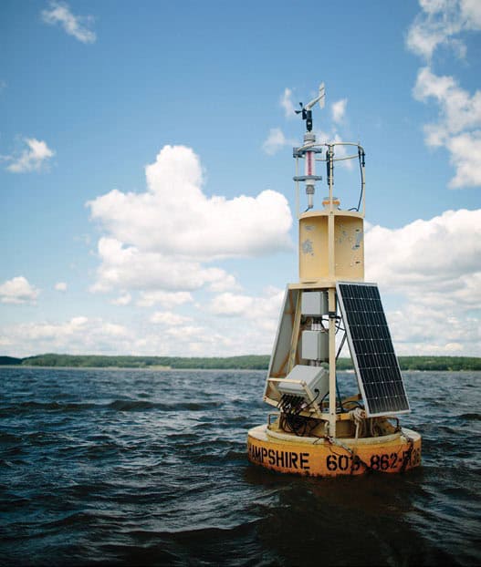
Figure 1: The Great Bay Buoy has been in operation since 2005. The original buoy was replaced in 2022 through contributions from NHDES, PREP, UNH, the Alliance for Coastal Technologies, IOOS, and NERACOOS. The buoy and associated sensors collect critical data for understanding differences between estuarine dynamics and those of the Gulf of Maine ecosystem. Photo by Jackson Estuarine Lab, UNH
Conditions in our estuaries are shaped by local processes but are also influenced by ecosystem dynamics operating at larger scales such as the Gulf of Maine. The following is a brief overview of key changes detected by the regional ocean observing system managed by the Northeastern Regional Association of Coastal Ocean Observing Systems (NERACOOS) as part of the U.S. Integrated Ocean Observing System (IOOS), the backbone of which is a network of buoys stationed along the Gulf of Maine coastline and at selected offshore locations (Figure 1). Data from the buoy network are supplemented by autonomous underwater gliders, land-based high-frequency radar stations, coastal sensors, ship-based surveys, and other tools. For more information, visit NERACOOS.org.
Long-term Regional Trends
It has long been documented that the Gulf of Maine is warming faster than almost any other ocean ecosystem on Earth. This trend continued in 2021 as the most significant marine heat wave since 2012 was felt across the Gulf. By mid-January 2021, daily average temperatures on the Eastern Maine Shelf began to reach or exceed the maximum values observed over the past 20 years, and temperatures did not fall below the 20-year average the entire year except for one brief instance (Figure 2). Air temperatures during the winter of 2020-2021 were not abnormally warm and the water temperature anomaly was observed throughout the water column rather than solely at the surface, suggesting that the marine heat wave was driven by oceanic rather than atmospheric influences. Furthermore, extreme temperatures were observed at stations progressively downstream along the Maine Coastal Current, following the dominant counterclockwise circulation trend in the Gulf.
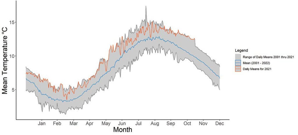
Figure 2: Daily average surface temperatures at NERACOOS Buoy I on the Eastern Maine Shelf in 2021 (orange line) relative to the daily 20-year average (blue line) and range (gray shaded area). Data source: NERACOOS
Partly due to changes in temperature, an ecological change that is becoming increasingly clear in the Gulf of Maine is a fundamental restructuring at the base of the food web. In particular, the lipid-rich copepod, Calanus finmarchicus, has long been a dominant species of zooplankton that is responsible for vital trophic linkages between primary producers (e.g., phytoplankton) and higher-level predators. Calanus are the major prey for the critically endangered North Atlantic right whale as well as forage fishes such as Atlantic herring and sand lance. In turn, these fishes are important prey for humpback whales, Atlantic cod, and other economically important marine mammals and fishes. Monitoring reveals that Calanus abundance in the Gulf of Maine has been below average in recent years (Figure 3), corresponding to shifting temperatures, salinity, and other environmental conditions. If Calanus abundance declines to a level that is too low to consistently support fishes and whales, there are likely to be critical consequences for river herring and striped bass, as well as industries that depend on these and other affected species (especially fisheries and ecotourism).
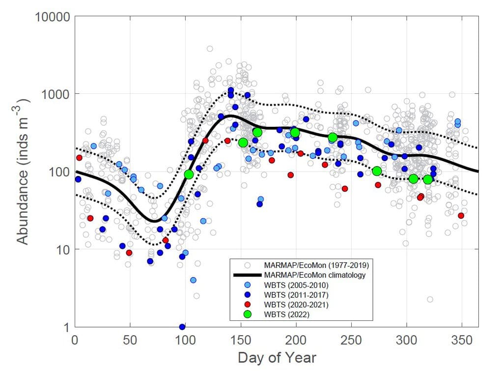
Figure 3: Long-term trends (top) in abundance of the copepod Calanus finmarchicus measured by the NOAA MARMAP and EcoMon programs, and at the Wilkinson Basin Time Series (WBTS) Station. Newer WBTS data points from the sampling program implemented by the Integrated Sentinel Monitoring Network, with support from the Marine Biodiversity Observation Network, are colored red (2021) and green (2022) to illustrate the low abundance observed in recent years. Note that this abundance is expressed on a logarithmic scale. Data source: NOAA and Woods Hole Oceanographic Institution
Emerging Issues
Although Harmful Algal Blooms (HABs) are not a new phenomenon in the Gulf of Maine, there are signs that they are becoming more problematic. This is due to the emergence of new HAB species in the region, notably the first documentation of Pseudo-nitzschia in 2012, as well as changing conditions that can promote increased frequency and severity of blooms of all HAB species. Warmer water temperatures foster the development of HABs, as do increasing precipitation rates. Increases in temperature and precipitation also affect nutrient dynamics, which in turn drive HAB dynamics. More frequent and severe HABs have important implications for human health, recreation, and seafood production.
Another emerging issue is the rising concentration of CO2 in the atmosphere and oceans, which is contributing to ocean and coastal acidification (OCA). Increased acidity in our coastal and ocean waters can pose a problem for shell-forming species (e.g., lobsters, oysters, clams, etc.), slowing the growth of new shell and, under extreme conditions, degrading existing shell. While the dynamics of OCA and its linkages to factors such as freshwater inputs and changing precipitation patterns are complex, understanding the impacts of OCA will be crucial given the high importance of these species to fishing communities and shellfish growers in the Northeast.
Finally, high-tide flooding constitutes another emerging issue warranting attention. An analysis of the first eight years of data from a tidal gauge at the mouth of the Hampton-Seabrook Estuary revealed that high tide flooding (greater than 10 ft above mean lower-low water) occurred on 36% of days monitored (Figure 3), with prospects for more frequent flooding as sea-level continues to rise. Sea-level rise interacts with long-term tidal cycles, making it harder to discern different signals and underscoring the importance of long-term time series.
Acknowledgments and Credit
Jake Kritzer (NERACOOS)